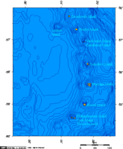
Douglas Strait
Douglas Strait is a strait 2 nautical miles (4 km) wide between Thule Island and Cook Island, in the South Sandwich Islands. The existence of this strait was first noted by a Russian expedition under Fabian Gottlieb von Bellingshausen in 1820. It was charted in 1930 by Discovery Investigations personnel on the Discovery II and named for Vice-Admiral Sir Percy Douglas, a member of the Discovery Committee.
Read article
Top Questions
AI generatedMore questions
Nearby Places
Operation Keyhole
1982 British military operation during the Falklands War

Cook Island, South Sandwich Islands
Island in the Southern Thule group of the South Sandwich Islands

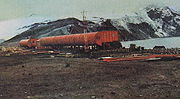
Corbeta Uruguay base
Former Argentine military outpost in the South Sandwich Islands (1976–1982)

Hewison Point
Easternmost point of land on Thule Island
Herd Point
Mount Holdgate
Volcano on Cook Island in the subantarctic
Mount Larsen (South Sandwich Islands)
Mountain in the South Sandwich Islands

Southern Thule
Island group in the South Sandwich Islands